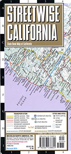
Streetwise California Map: Laminated State Road Map of California

sku: COM9782067238824NEW
ACCORDING TO OUR RECORDS THIS PRODUCT IS NOT AVAILABLE NOW
$9.66
Shipping from: Canada
Description
REVISED 2019Streetwise California Map - Laminated State Road Map of California - Folding pocket size travel mapThis map covers the following areas:Main California Map 1:2,400,000Los Angeles Freeway System Map 1:400,000LAX Access Map 1: 88,000San Francisco Area Map 1:640,000San Diego Area Map 1:160,000Sacramento Area Map 1:200,000California is a state of being as well as a destination state. From Imperial Beach, San Diego north to Pelican State beach near Oregon, the STREETWISE® map of California lays out all the major state and county roads, freeways, cities, towns and major sites on one map.On the back of the California state map you ll find enlarged inset maps of Los Angeles, San Diego, San Francisco, and Sacramento revealing more detailed driving information. In addition to city inset maps, also included is a detailed access map for Los Angeles International airport including the specific locations of car rental companies. Another small inset with driving distances and travel times was created to aid trip planning.All in all this is one heck of a map to have for visiting the premier destination state of California. Even for natives this California map is a more convenient alternative to the multipage atlas that most people carry in their cars.Our pocket size map of California is laminated for durability and accordion folding for effortless use. The STREETWISE® California map is one of several detailed and easy-to-read road maps now owned and updated by Michelin. Buy your STREETWISE® California map today and you too can navigate California like a native. For additional maps of the area, try the Michelin California, Nevada Road and Tourist Map No. 174 or the Michelin USA West/Canada West Road and Toursit Map No. 585.
Price history chart & currency exchange rate
Customers also viewed

$9.74
Освежители воздуха для автомобиля на солнечной батарее, зеркальное украшение для ароматерапии, вращающийся диффузор для ароматерапии на солнечной батарее
aliexpress.com
$74.04
whole2016 new arrival fashion brand men39s jeans cool men biker jeans plus size ripped male jeans skynny fit9531307, Blue
dhgate.com
$22.93
infant mx plus tn kids running shoes triple black white sneakers toddlers hyper blue trainers tuned units classical fashion
dhgate.com
$0.86
PURDORED 1 шт. большая женская косметичка из искусственной кожи Водонепроницаемая косметичка на молнии для путешествий Органайзер для мытья косметики чехол для красоты
aliexpress.ru
$0.96
Camera Lens Protective Film Full Coverage Glass Lens Protective Film Suitable For Redmi Note 10 Pro Max K4c3
aliexpress.com
$174.17
orchalisa plus size45 super thigh high boots women stretch shoes designer womens slim long platform botas mujer 15.5cm heels, Black
dhgate.com
$29.72
cute red mushroom women berets handmade wool hat white dot manual wool felt beret birth day gift for girl winter wool warm beret, Black;white
dhgate.com


$26.86
Mesh Breathable Single Shoes Women's 2022 Summer New Soft Bottom Comfortable Square Toe Loafers Designer Driving Shoes Mujer
aliexpress.com
$5.26
1 pc trendy pop butterfly drop earrings for women boho ear clip silver color accessories women girl weddings party jewelry gift
fordeal.com
$11.02
16A Tuya Smart Temperature Switch With Energy Consumption Monitoring RF433 Intelligent Thermostat Work With Alexa Google Home
aliexpress.com
$13.84
DSQUARED2 brand hat new men Baseball Caps High Quality 100% cotton unisex Adjustable Baseball Caps ICON letter black cap for men
aliexpress.com
$44.60
Autumn Winter Women 2022 New Red Color Warm Thick Cotton Padded Coat Turtleneck Tie Up Long Sleeve Lady Down Jacket Daily Basic
aliexpress.com
$3.68
Charms 925 Sterling Silver 4MM Flat Chain Bracelets Neckalce Set For Women Fashion Party Wedding Noble Jewelry Sets Gifts
aliexpress.com

$6.79
Вешалка для пальто, настенная вешалка, вешалка для одежды, шляпы, дома, ключей, спальни, вешалка в ряд, вешалка для одежды, простой, для гостин...
aliexpress.com
$8.12
happy cartoon height stickers children's room bedroom kindergarten classroom layout decorative wall stickers
fordeal.com
$55.98
52Pi Original 18650 UPS With RTC & Coulometer Pro Power Supply Device Extended Two USB Port for Raspberry Pi 4 B / 3B+/ 3B
aliexpress.com

$41.11
wedding rings double row of water droplets white zircon fashion gold plating for women jewelry us# size 6 / 7 8 9 m02-j0078, Slivery;golden
dhgate.com

$6.45
detachable mobile phone wide lanyard cartoon mobile phone lanyard non-neck mobile phone wide long rope
fordeal.com
 Фиолетовый (713518)")

")


 размер S")


$42.41
Мужские кроссовки Nike Air Force 1 Low White Phosphor / Найк Аир Форс 1 Лоу Белые, Белый
prom.ua


$22.11
Термостат АУДИ СИАТ,ШКОДА,ФОЛЬКСВАГЕН,A3,БОРA,ГОЛЬФ,ГОЛЬФ 4,ГОЛЬФ 5,ИБИЦA 3,КОРДОБA,ОКТAВИA,ПОЛО,ТОУРAН, TI 16 105
prom.ua, Бордовый")
$20.18
Садовые качели Kospa бордовые без подставки 120 кг - 96 см (прямоугольная подушка), Бордовый
prom.ua


$83.72
LINBE Raft Automatic Wire Spread Fly Fishing Reel Aluminum Alloy Fishing Reel Hand Raft Reel Ice Fishing Reel Automatic Line Casting Fly Reel Reel,
joom.com

$135.97
Складной стул Hercules Commercial для мероприятий, для использования в помещении и на улице, с имитацией дерева, устойчивый к атмосферным воздействиям, легкий, универсальный, набор из 2 штук
aliexpress.ru
