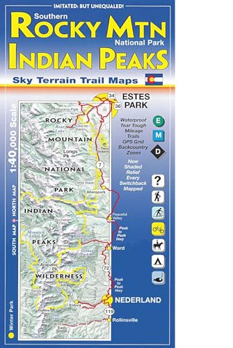
Southern Rocky Mountain National Park & Indian Peaks Wilderness Trail Map

sku: COM9780966550825NEW
ACCORDING TO OUR RECORDS THIS PRODUCT IS NOT AVAILABLE NOW
$18.97
Shipping from: Canada
Description
Waterproof & Tear Tough. Two detailed large scale 1:40,000 scale topographic maps cover the alpine terrain northwest of Denver & Boulder, with extensive trail descriptions, trail ratings, newly named peaks, shaded relief, backcountry info & full UTM grid for use with GPS. Noteworthy points mapped include Longs Pk, McHenrys Pk, Flattop Mtn, Bear Lake, Estes Park, Moraine Park, Glacier Basin, Arapaho Glacier, Jasper Lake, Nederland, Rollinsville, Tollland, Wild Basin, Rollins Pass, Brainard Lake, St Vrain Glaciers, and much more. Please note this map covers about 45% of RMNP: the south eastern portion, the most popular part. 5th Edition has brand new shaded relief that looks great, and every switchback is mapped in eye pleasing clarity.
Price history chart & currency exchange rate
Customers also viewed

$26.59
Backpack for Men Women, Water-Resistant School Backpack Bookbag Schoolbag Casual Daypack Work Navy
aliexpress.ru

$489.37
Приставной столик Мини-столы для комнаты Сервисный современный журнальный столик Угловые низкие прикроватные тумбочки в гостиничном зале Центр Tisch Легкий обеденный телевизор
aliexpress.ru
$117.89
Upholstered Platform Queen Size Bed Frame with Headboard Premium Stable Wood Slat Support No Box Spring Required Light Grey
aliexpress.com
$15.43
4 шт. металлический передний и задний амортизатор для Traxxas Latrax Teton Desert Prerunner SST 1/18 обновленные детали для радиоуправляемых грузовиков и автомобилей
aliexpress.ru


$86.11
Итальянские Роскошные зеркальные настенные светильники Atlantis с цепочкой, бра для ванной, лампа для спальни в стиле лофт, Декор
aliexpress.ru
$14.39
6mm 8mm Dropshipping Rose Gold Couples Hammered Engagement Ring Fashion Men Women Wedding Band I Love You Engraved Comfort Fit
aliexpress.com
$13.63
1 шт., маркировочная машина, 6 позиций, автоматическая нумерация в номер, страницы кодирования, раздел, маркировочная машина, цифровой штамп
aliexpress.ru![Подшипник опоры переднего амортизатора VOLKSWAGEN CADDY III [2004-] Skoda, FABIA II [2006-]](http://images.ua.prom.st/1919555992_w640_h640_podshipnik-opory-perednego.jpg "Подшипник опоры переднего амортизатора VOLKSWAGEN CADDY III [2004-] Skoda, FABIA II [2006-]")
$8.82
Подшипник опоры переднего амортизатора VOLKSWAGEN CADDY III [2004-] Skoda, FABIA II [2006-]
prom.ua


$15.16
fancy selenite amethysts labradorite spiritual moon bracelet healing beaded woman ladies purple stone bracelet7682796, Golden;silver
dhgate.com
$15.83
darlingaga streetwear black hole long sweatshirt women casual oversized hoodie pullover autumn winter sweatshirts dress clothes y200610
dhgate.com
$72.81
designer bag embossed baguette bag flap crossbody bags shoulder messenger handbag women tote bag letter purse vintage flower cross body leat
dhgate.com
$142.30
100ml x 50 round empty clear cosmetic spray bottle with gold collar 100g perfumes sprayer pump container for toilet waterhigh qual4208615
dhgate.com
$48.09
women's sandal fashion summer shoes women's flat sandal rubber shoes square headed sandal slipper shoes for women sandals
fordeal.com
$3.08
Car Holder Visor Sunglasses Mount Glasses Clip Eyeglasses Organizer Hanger Sunglass Universal Ticketholders
aliexpress.ru
$3.89
2,4-9 мм сверхмощный кабель на молнии, стяжки, Автоматическое Натяжение, отрезной инструмент, плоскогубцы, крепежный инструмент для нейлоново...
aliexpress.ru
$442.97
HILTI TE-7/TE-7-C Electric Hammer Drill High-power Impact Drill Electric Pick Three-purpose Multi-function Power Tool
aliexpress.com
$10.07
Детская Радужная подходящая игра монтессори игрушка Радужная стакан подсчет медведь цветной вес сенсорная игрушка Монтессори игрушка
aliexpress.ru
$13.58
Коньяк кожаная сумка-тоут, Наплечная Сумка, коньяк сумка для женщин, ежедневная Сумка, женская кожаная сумка, большая сумка на выходные
aliexpress.ru
$7.44
Cartoon Lion Style Breathable Knitting Wool Hat Clothes Suit Newborn Photography Outfits Clothes Baby Clothing Baby Photo Props
aliexpress.com
$0.85
Брелок Amaxer пиво открывалка для бутылок брелок для автомобиля подарок на день рождения для друзей и семьи
aliexpress.com
$3.51
Acrylic Octagon Napkin Rings Transparent Decorative Napkin Buckle for Wedding Banquet Party Dinner Table Decoration
aliexpress.ru
$3.15
With Horns Cute Protective Shell Phone Case For Samsung Galaxy A72 A52 A32 Note 20 S21 S20 Plus Rainbow Glitter Back Cover Coque
aliexpress.ru
$10.79
Однотонный женский повседневный костюм из 2 предметов, Женский офисный комплект, Осенний женский кардиган с длинным рукавом, Блейзер, 2022
aliexpress.ru

$0.63
Нейлоновая крышка двигателя триммера A0KF, водонепроницаемая Пылезащитная Крышка для триммера для травы, набор аксессуаров для пилы
aliexpress.com

$59.49
synthetic wigs silky straight natural black wig long lace front for women color heat resistant hair 18-26 inches
dhgate.com
$194.39
220v household wall-mounted electric heater waterproof energy-saving 3rd gear ptc ceramic heating air conditioner for winter1
dhgate.com
$25.21
aimsnug female t-shirt cat striped print women's latest 2021 summer half sleeve loose v-neck tees shirt casual pullovers, White
dhgate.com
$212.03
N501VW Motherboard 8GB RAM i7-6700HQ For Asus N501VW N501V G501VW laptop Motherboard N501VW Mainboard N501VW Motherboard test ok
aliexpress.com
$29.72
2019 brand men shirt valknut odin symbol celtic knot norse viking runes t shirt sport hooded sweatshirt hoodie
dhgate.com
$24.54
Sricam SP018 WifI IP Camera PTZ 4x Digital Zoom Security Camera Support Micro SD Card CMOS P2P 2MP CCTV Full HD 1080P Camera
aliexpress.com
$68.27
100% S925 sterling silver bracelet personality simple fashion style domineering opening styling to send a gift jewelry Bangles
aliexpress.com


