Nonfiction Reading and Writing Workshop a: Making Inferences: Guided Instruction Book

sku: COM9780792250166USED
ACCORDING TO OUR RECORDS THIS PRODUCT IS NOT AVAILABLE NOW
$8.63
Shipping from: Canada
Description
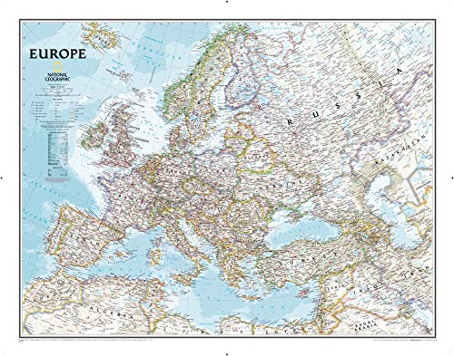
National Geographic's Classic political map of Europe features clearly defined international boundaries, thousands of place names, water bodies, airports, major highways and roads, national parks, and much more. The tasteful color palette, shaded relief, and coastal bathymetry make this map as attractive as it is functional. The countries and major cities shown include: Albania, Armenia, Austria, Azerbaijan, Belarus, Belgium, Bosnia & Herzegovina, Bulgaria, Croatia, Cyprus, Czech Republic, Denmark, Estonia, Finland, France, Georgia, Germany, Greece, Hungary, Iceland, Ireland, Italy, Kosovo, Latvia, Liechtenstein, Lithuania, Luxembourg, Macedonia, Moldova, Montenegro, The Netherlands, Norway, Poland, Portugal, Romania, Russia, Serbia, Slovakia, Slovenia, Spain, Sweden, Switzerland, Turkey, Ukraine, and the United Kingdom. The map is encapsulated in heavy-duty 1.6 mil laminate which makes the paper much more durable and resistant to the swelling and shrinking caused by changes in humidity. Laminated maps can be framed without the need for glass, so the fames can be much lighter and less expensive.
Price history chart & currency exchange rate
Customers also viewed

$10.53
Комплект колокольчиков для рук, аксессуары для барабанов, комплект аксессуаров для дождевых барабанов, держатель для барабанных палочек, наклейки с номерами, барабанная палочка, колокольчик от дождя
aliexpress.ru
$13.33
7 шт. 15-55 мм твердосплавный наконечник HSS сверло набор кольцевых пил набор зубьев резак инструмент для нержавеющей стали металл дерево сплав
aliexpress.ru

$13.84
Аксессуары для куриных платьев, повязка на голову, украшение, набивные животные для девочек, фотореквизит
aliexpress.com
$52.96
Motorcycle Side Fairing Covers Body Decorative Trim For Honda Gold Wing GL 1800 Goldwing Tour DCT GL1800 F6B 18-23
aliexpress.com
$41.71
Straight Bob Fringe Wig With Bang Human Hair 3x1 HD Lace Closure Wig Full Machine Made Glueless Wear And Go 8-16 Inch Bob Wigs
aliexpress.com
$5.52
Неоновые психоделические грибы, Панама для унисекс, летние солнцезащитные шляпы, стильные складные для фотографий
aliexpress.com
$9.17
Winter Silver Gradient Boys Girls Sport Shoes PU Warm Plush Sneakers For Kids Hook Loop Soft Non Slip Children Running Shoes
aliexpress.com
$13.27
Женское платье в стиле ретро, новинка 2023, повседневные свободные однотонные мини-платья с оборками и длинным рукавом, элегантное женское Клубное платье на весну и осень
aliexpress.com
$6.95
Popular Men Jacket Long Sleeve Autumn Winter Drawstring Hood Windbreaker Sporty Men Coat for School
aliexpress.com
$4.54
Pencil Shape Pen Holder Silicone Waterproof Storage Bucket Creative Stationery Storage Stationery Storage Box Students
aliexpress.com
$4.14
LED Night Lights Mushroom Shape Automatic Sensor Toilet Bedroom Decor Wall Lamps Light-control Sensor Bedroom Light
aliexpress.com
$38.14
24ss VTM Oversized Black Sweatshirts Men Women 1:1 Best Quality Letter Logo Embroidery Hoodies
aliexpress.com
$5.78
Smart Phone Base Holder Cell Vehicle Mount Aluminum Alloy Adjustable Cellphone Car
aliexpress.com
$111.33
5yards 3D Beads Lace Fabric 2023 High Quality Mesh Embroidery Applique 3D Flower Tulle Nigerian Lace Fabrics For Bridal
aliexpress.ru


$2.73
Большие штампы в форме сердца, новые товары в 2023 году, формы «сделай сам», скрапбукинг, изготовление бумаги, режущие изделия, шаблон, карта ручной работы
aliexpress.ru
$1.61
Экологически безопасные аксессуары для собак, уход за зубами, Фотофон для домашних животных, интерактивная игрушка для щенков, резиновые товары для собак
aliexpress.ru
$4.38
10 Sets of Antique Bronze Lion Head Handle Cabinet Door Hardware Handle for Home Decoration
aliexpress.ru, возраст")
$4.59
Летнее платье с цветочным принтом, без рукавов, на толстых бретельках, женское облегающее мини-платье с оборками, стильные платья с длинным рукавом, длина рукава (см), возраст
aliexpress.ru

$18.39
Модуль Wi-Fi, E-порт, Интерфейсный серверный порт Linux, TTL последовательный для Ethernet, встроенный модуль DHCP 3,3 В, TCP IP Telnet
aliexpress.ru
$10.23
JCID-D11 Многофункциональный цифровой детектор с поддержкой Bluetooth, соединение с JC, чертежи для измерения напряжения печатной платы
aliexpress.ru
$20.92
stone pattern mini crossbody bags for women 2021 pu leather shoulder purse fashion designer summer handbags
dhgate.com
$55.28
52L Motorcycle Trunk Electric Car Trunk Enlarged Capacity Safety Thickened Battery Pedal Storage Kit Universal Luggage Trunk
aliexpress.com
$1.42
MaiYaCa Shawn Mendes Phone Case for iPhone 11 12 13 mini pro XS MAX 8 7 6 6S Plus X 5S SE 2020 XR case
aliexpress.com
 (4.7\"), Черный")
$4.44
TPU+Glass чехол GLOSSY Logo Full camera для Apple iPhone 7 / 8 / SE (2020) (4.7"), Черный
prom.ua

$44.51
cycling jersey sets 2021 spring long sleeves bike racing mtb profession females' suits bicycle anti-pilling sportswear, Black;blue
dhgate.com
$46.95
For BYD Song Plus-EV Outdoor Protection Full Car Covers Snow Cover Sunshade Waterproof Dustproof Exterior Car accessories
aliexpress.com")
$25.40
Женский модный тонкий свитшот на флисовой подкладке в корейском стиле: Весенне-осенний кардиган с капюшоном для студентов M (90-105 jin)
joom.com