Folded Map: Fort Worth Street Map

sku: COM9780528008894USED
ACCORDING TO OUR RECORDS THIS PRODUCT IS NOT AVAILABLE NOW
$20.39
Shipping from: Canada
Description
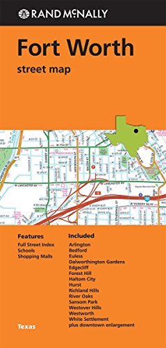
Rand McNally's folded map for Fort Worth is a must-have for anyone traveling in and around this part of Texas, offering unbeatable accuracy and reliability at a great price. Our trusted cartography shows all Interstate, U.S., state, and county highways, along with clearly indicated parks, points of interest, airports, county boundaries, and streets. The easy-to-use legend and detailed index make for quick and easy location of destinations. You'll see why Rand McNally folded maps have been the trusted standard for years. Regularly updated Full-color maps Clearly labeled Interstate, U.S., state, and county highways Indications of parks, points of interest, airports, county boundaries, schools, shopping malls, downtown & vicinity maps Easy-to-use legend Detailed & full street index Convenient folded size © 2014Communities Included: Arlington,Bedford, Euless, Dalworthington Gardens, Edgecliff, Forest Hill, Haltom City, Hurst, Richland Hills, Rover Oaks, Sansom Park, Westover Hills, Westworth, White Settlement plus downtown enlargement.
Price history chart & currency exchange rate
Customers also viewed


$3.82
10Pcs 5W 1 ohm R 1ohm 1R Horizontal Ceramic Cement Power Resistor Resistance 5% Free shipping High Quality
aliexpress.com


/sumka-aldo-minibaro-13601061-500.jpg "Сумка Aldo Minibaro 13601061 500, Фіолетовий")

$24.48
Berets Men's And Women Casual Sboy Hat Autumn Retro Beret Fashion Wild Cap Unisex Pu Women's Solidberet Hats, Creamy-white
dhgate.com

$20.00
2021 polo homme de marque striped customizable pattern stitching black men's polos shirt 3XL vw polo tshirt
alibaba.com
$30.59
Fur Neck Coat Women Plus Size Long Cloak Casual Loose Ladies Jacket Warm Cape Coats Abrigos Mujer 2019 Autumn Winter, Black
dhgate.com
$69.00
sneakers women 2020 summer vulcanize shoes breathable rainbow color fashion casuals height increasing female chunky ladies #s17g
dhgate.com

$620.08
Large luxury interior wood texture abstract hotel sculpture home decoration, home and hotel wooden crafts
aliexpress.ru
$18.52
Good Car Ceramic Nano Coating Nanos Crystalline Hydrophobic Layer Car Polishing Coating Waterproof Anti Fog Brightening Nano Coa
aliexpress.com
$6.72
12V Motorcycle Spotlights Switch Turn Signal Lights Control Fog Lamp Buttons Light Toggle Waterproof Motorbike Accessories
aliexpress.com
$25.02
Ceramic Snack Tray Bunny Design Dessert Fruit Serving Plate for Cakes Nuts Dried Fruits Candies Jewelry Display Home Party Decor
aliexpress.com
$37.66
GR Greek Mineral Gray Keyboard Upper Case Palmrest Shell Cover For Lenovo ThinkBook 14 14IML 14IIL 5CB0W44353
aliexpress.com
$62.48
Натуральная кожаная женская сумка через плечо класса люкс от дизайнерского бренда, модная дамская сумочка из воловьей кожи для женщин
aliexpress.ru
$54.43
For Labubu Clothes 38cm Pilot Costume For Zimomo Jump For Joy Dolls Stylish Airplane Outfit Dolls Accessories Fast Shipping Gift
aliexpress.com
$17.99
Soviet Union Badge USSR Personal Courage Medal Gold Star Enamel Metal Save Lives Maintain Order Event Pin Brooch Souvenir Gifts
aliexpress.com
$59.02
AILANG Brand Luxury Double Tourbillon Mechanical Watch for Men Stainless Steel Waterproof Automatic Watches Mens Reloj Hombre
aliexpress.com
$520.86
Lifting desk Solid wood black study Double home computer Electric intelligent study table
aliexpress.com
$1,000.00
S Shape Machine 30K Ultrasound RF EMS Vacuum Body Face Care 160MW Laser Machine
aliexpress.com
$3.04
Беспроводной портативный автомобильный и мотоциклетный насос Makita с цифровым дисплеем для подкачки шин
aliexpress.ru")
$67.38
Акустические панели из пеноматериала, 4 шт. - Звукоизоляционные стеновые панели высокой плотности для снижения шума в студии, домашнем кинотеатре и офисе (черные)
aliexpress.ru
$10.13
Новинка: Женское летнее платье миди с принтом, утягивающее талию, с кружевной отделкой, из полиэстеровой смеси
aliexpress.ru
$27.61
Новые европейские модные квадратные солнцезащитные очки для женщин, премиальные ретро-очки с защитой от ультрафиолета, стильные и модные солнцезащитные очки.
aliexpress.ru
$4.50
Игрушка-антистресс в форме паровых булочек, сенсорная игрушка-прикол для снятия стресса, для детей, подростков, взрослых, женщин и мужчин
aliexpress.ru
$320.00
Подставка для фуршета из акрила, 11 предметов: для десертов, свадебных банкетов, тортов, фруктов, суши, чаепитий, декора стола, демонстрации еды на мероприятиях
aliexpress.ru
$17.70
Summer New Women's Shoes Exquisite Rhinestone High Heeled Sandals for Woman Elegant Casual Shoes Designer Shoes Sandalias Mujer
aliexpress.ru


$46.83
Мужская ветрозащитная хлопковая куртка с капюшоном, утепленная, удлиненная, с воротником-бомбер, молодежная, трендовая, осенняя, модная верхняя одежда
aliexpress.ru
